

Wöppelmann Guy
Cet article est disponible en français
- Team : DPL
- Status : Researcher
- guy.woppelmann-at-univ-lr.fr
- Tél. : +33(O)5 46 45 86 13
Professor in Earth Sciences
La Rochelle University
Associated scientific institute at CNRS: INSU
Corresponding member of the BDL since 2022
Key words : Vertical land motion, space geodesy, GNSS methods, sea level change, tide gauges
CV & Publications
Publications
Research interests
- vertical displacements of the Earth’s surface at the coast using space geodetic methods (GPS, InSAR...);
- sea level change over the past decades to century timescales using tide gauges;
- performances of modern tide gauge technologies (acoustic, radar) and explore new ones (e.g., GNSS-IR);
- data archeology: rescue, digitization and quality control of historical sea level records;
- detection of spatial fingerprints of contemporary land ice melting in sea level records by combining in situ and satellite data;
- unification of vertical references, in particular chart datums.
An example of tide gauge and GPS data combination:
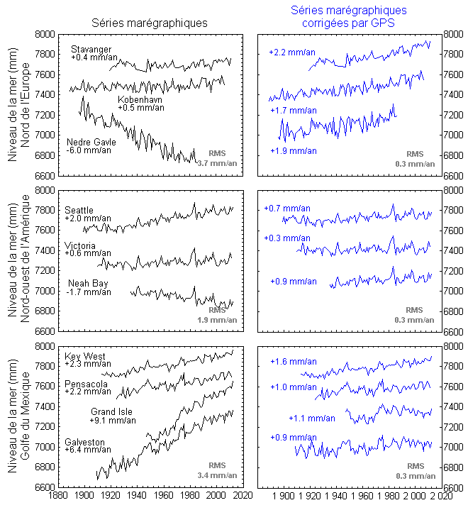
The figure on the right (click on the image to enlarge) shows how well can work corrections of tide gauge records using GNSS (GPS) velocities obtained from a state-of-the-art data analysis strategy. The left panels display annual mean sea levels from high-quality tide gauge records in three different regions of the world coasts (data available at the PSMSL international service). The right pannels show these records corrected for vertical land motion using GPS velocities from our fifth solution of the ULR consortium. The spread observed in the rates of sea level change in the left panels is substantially reduced in the three regions (standar deviation of 0.3 mm/year). These results are updated from Wöppelmann et al. (2009).
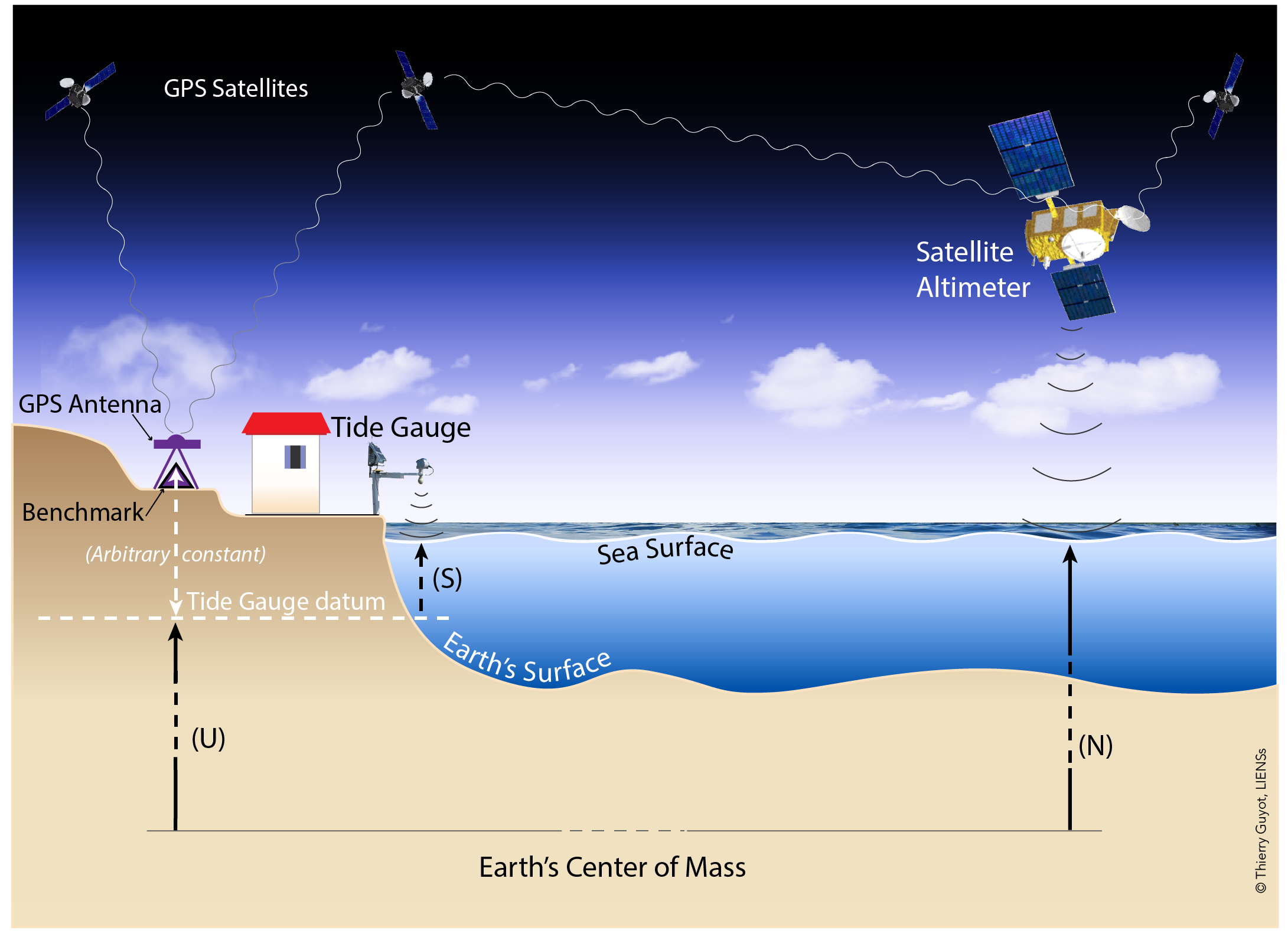
In the illustration on the left (click on the image) are represented the principal elements of the observational situation at a tide gauge. Satellite radar altimetry plays an increasing important role in sea level observation. However, to be useful for coastal studies on impacts (submersion, erosion, civil engineering, etc), its data requires a correction in order to transform the satellite geocentric sea levels into relative sea levels with respect to the land. High-precision GPS methods, for instance, can provide this supplementary data such as S = N - U (notations from the illustration) in the idealized case study depicted in the illustration. The situation can indeed be more complex, in particular because here is assumed that the tide gauge and the satellite are observing the same sea levels at the coast and offshore, respectively.
Articles representative of my scientific activities (6):
- Pira A., A. Santamaría-Gómez., Wöppelmann, G. (2026). Ground-based high-frequency sea level monitoring from multi-GNSS reflectometry using extended Kalman filtering. GPS Solutions, Vol. 30, Art. 31.
- Gravelle M., G. Wöppelmann, K. Gobron, et al. (2023). The ULR-repro3 GPS data reanalysis and its estimates of vertical land motion at tide gauges for sea level science. Earth System Science Data, 15, 497–509.
- Poitevin C., G. Wöppelmann, D. Raucoules, et al. (2019). Vertical land motion and relative sea level changes along the coastline of Brest (France) from combined space-borne geodetic methods. Remote Sensing of Environment, 222, 275-285.
- Dangendorf S., M. Marcos, G. Wöppelmann, et al. (2017). Reassessment of 20th century global mean sea-level rise. Proc. Natl. Acad. Sci. USA, 114, 5946-5951.
- Wöppelmann G. & M. Marcos (2016). Vertical land motion as a key to understanding sea level change and variability. Reviews of Geophysics, 54, doi:10.1002/2015RG000502.
- Wöppelmann G., M. Marcos, A. Coulomb, et al. (2014). Rescue of the historical sea level record of Marseille (France) from 1885 to 1988, and its extension back to 1849-1851. Journal of Geodesy, 88, 869-885.
(Complete personal bibliography)
Contribution to books:
- Marcos, M., G. Wöppelmann, F. M. Calafat, et al. (2022). Mediterranean Sea Level. In Oceanography of the Mediterranean Sea (Chapter 5), ISBN: 978-0-12-823692-5.
- Wöppelmann G., M. Gravelle, L. Testut (2021). SONEL sea-level observing infrastructure: French contribution to the IUGG Centennial in 2019, and beyond. Collection du Bureau des Longitudes, Ed. C.Boucher, 1, pp. 43-53, ISBN : 978-2-491688-08-0.
- Wöppelmann G. & P. Pirazzoli, 2019. Tide gauges. In Encyclopedia of Earth Sciences, Springer Science and Business, pp. 1743-1746, doi:10.1007/978-3-319-93806-6_322.
- Bureau des longitudes (2009). Les Observatoires. Observer la Terre. Ed. Hermann, 309 pp., ISBN 978-27056-6946-1.
Scientific and administrative responsibilities (current)
- since 2001: Member of the Group of Experts of the GLOSS program under the auspices of the IOC/UNESCO, in particular national focal point between 2004 and 2015, and member of the steering committee since 2022.
- since 2011: In charge of the GNSS at tide gauge data assembly center of the GLOSS program of the IOC/UNESCO, hosted at SONEL.
- since 2024: Member of the FIG WG4.5 "Climate Change induced Sea Level Rise and Adaptation".
- since 2025: Member of the Consortium Board of the European EPOS Thematic Core Service GNSS.
- since 2025: member of the Governing Board of the International GNSS Service (IGS), Co-chair of the IGS Tide Gauge (TIGA) Pilot Project.
Ph-D. Thesis Supervisions
- Chicot G. (2025-ongoing). Impacts des mouvements verticaux du sol et de la variabilité climatique interne sur l’évolution des niveaux marins récents et futurs en région Nouvelle Aquitaine : Application aux submersions chroniques. La Rochelle Université, Soutenance prévue en 2028.
- Pira A. (2022-ongoing). GNSS-Reflectometry applied to sea level observation at high-frequency sampling and its extremes in hostile coastal areas. La Rochelle University, Viva scheduled in Autumn 2025.
- Challis J. (2020-2024). Temporal evolution of tidal characteristics on the north-west European continental shelf. La Rochelle University in collaboration with BRGM and Shom, defended 27th August 2024.
- Poitevin C. (2015 - 2019). Variabilité du niveau marin relatif le long du littoral de Brest (France) par combinaison de méthodes géodésiques spatiales (altimétrie radar, InSAR et GPS). Thèse de doctorat de l’université de la Rochelle, soutenue le 29 mai 2019.
- Sakic P. (2013 - 2016). Apport de la géodésie de fond de mer à l’évaluation de l’aléa sismique côtier : distancemétrie en mer de Marmara et simulation GNSS/A aux Antilles. Thèse de doctorat de l’université de la Rochelle, soutenue le 9 décembre 2016.
- Gouriou T. (2007- 2012). Evolution des composantes du niveau marin à partir d’observations de marégraphie effectuées depuis la fin du 18e siècle en Charente-Maritime. Thèse de doctorat de l’université de la Rochelle, soutenue le 26 mars 2012.
- Santamaria-Gomez A. (2007-2010). Estimation des mouvements verticaux de l’écorce terrestre par GPS dans un repère géocentrique, dans le cadre du projet TIGA. Thèse de doctorat de l’Observatoire de Paris, soutenue le 11 octobre 2010.
- Letetrel C. (2006-2010). Mouvements verticaux à la surface de la Terre par altimétrie radar embarquée sur satellite, marégraphie, et GPS. Thèse de doctorat de l’université de la Rochelle, soutenue le 25 août 2010.
- Pouvreau N. (2004-2008). Trois cents ans de mesures marégraphiques en France : outils, méthodes et tendances des composantes du niveau de la mer au port de Brest. Thèse de doctorat de l’université de la Rochelle, soutenue le 26 septembre 2008.