


SOMLIT


|

|

|
|---|
SOMLIT :
The Coastal Environment Observation Service (SOMLIT) is a National Observation Service (SNO) accredited by CNRS-INSU since 1996. Since 2016, it has been one of the basic networks of the Coastal and Marine Research Infrastructure (IR-ILICO).
Today, SOMLIT brings together 10 French coastal stations and marine laboratories along the English Channel, Atlantic and Mediterranean coasts, from Wimereux to Marseille via Brest. All SOMLIT teams follow common, standardized protocols.
SOMLIT aims to monitor changes in the marine environment over the medium and long term in order to understand how marine ecosystems respond to natural forcing and human-induced pressures through the study of multi-parameter time series.
SOMLIT observations cover marine hydroclimate, chemistry, biogeochemistry and the biology of the water column.
The common protocols require all participating teams to carry out the following :
Sampling at subsurface depth at high tide (± 1 hour), every 15 days ;
A surface-to-bottom profile using a multiparameter probe ;
Analysis of a set of 16 parameters ;
Implementation of a quality management approach in accordance with the NF EN ISO/IEC 17025 standard ;
Annual intercomparison exercises between CNRS and university laboratories, as well as participation in Ifremer interlaboratory proficiency tests.
SOMLIT makes all the results obtained available to national and international research communities through the SOMLIT national website.
SOMLIT in La Rochelle :
The LIENSs laboratory joined the SOMLIT network in 2012, following an initial implementation phase that began in June 2011.
The site is located in the Pertuis d’Antioche (between the islands of Ré and Oléron), 5 nautical miles from the port of Chef de Baie (La Rochelle), at a depth of 40 metres (blue dot on the map).
The site lies outside the areas affected by inputs from small rivers (the Lay, Sèvre and Charente) and away from major human activities (marine aquaculture, coastal fishing and dredging). It remains predominantly under oceanic influence, although its winter hydrological conditions are affected by the plumes of the Gironde and Loire rivers.
The site complements the hydrological monitoring stations of the pre-existing REPHY and WFD (Water Framework Directive) networks (yellow dots on the map), some of which are located near marine aquaculture areas (oyster and mussel farming).
Sampling is carried out at high tide, at a tidal coefficient of 70 (± 10), aboard the research vessel L’ESTRAN operated by the University of La Rochelle.

Seawater samples are collected using a Niskin bottle. Surface-to-bottom profiles are obtained using a Sea-Bird SBE 19plus multiparameter probe, while qualitative phytoplankton samples are collected using a phytoplankton net with a mesh size of 10 µm.

The seawater collected in the Niskin bottle is then transferred into containers selected for each parameter (O₂, pH, nutrients, pico- and nanoplankton), and the appropriate fixatives are added.


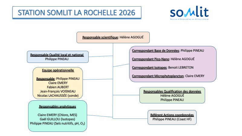
[Organizational chart :]
Contacts :
[Scientific coordinator :] Hélène Agogué, CNRS Research Scientist, tel. : 05 46 50 76 50
Email : helene.agogue@univ-lr.fr
[Quality manager :] Philippe Pineau, CNRS Engineer, tel. : 05 46 50 76 60
Email : philippe.pineau@univ-lr.fr
Last updated : January 2024]